• Skip to primary navigation
  • Skip to main content
logo of Alaska Center for Conservation Science

Alaska Center for Conservation Science

Fostering research, education, and collaboration on biological conservation and natural resource management in Alaska and the Arctic

  • Home
  • About
    • Staff, Faculty, and Students
    • Support Our Program
    • Opportunities
    • Contact
    • Our Partners
  • Research
    • Kachemak Bay National Estuarine Research Reserve
    • Invasive Species
    • Aquatic Ecology
    • Vegetation
    • Wildlife
    • Landscape Ecology
  • Data and Services
    • Data Catalog
    • Conservation Data Portals
    • Code Repository
    • Services
  • Publications
  • Landscape Ecology
  • Research
    • Ecological Change
    • Geospatial Synthesis
    • Vegetation Mapping
    • Herbivore Habitat
  • Data and Resources
    • Data Catalog
    • Vegetation Maps
  • Publications
  • People

Geospatial Synthesis

Landscape ecologists at ACCS have a big picture perspective seeking to develop statewide datasets that are informed by the best available local sources. With partners across Alaska, we have established standardized statewide datasets for a variety of applications, including a statewide assessment of landscape condition, a stream temperature monitoring network (AKOATS), a statewide vegetation plots database (AKVEG), and continuous foliar cover maps of vegetation components across arctic and boreal Alaska. Our statewide geospatial syntheses inform future management decisions and provide scientific baseline for effective biological conservation.

Anthropogenic Footprint

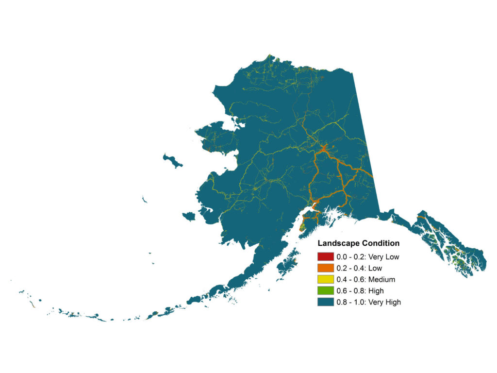
Understanding the current and historical extent of human development is an important component to effectively managing ecosystems. Habitat loss and fragmentation are the leading causes of species loss globally, and although Alaska is thought to be primarily intact, the location and intensity of development can have important impacts on local and regional resources. We work cooperatively with resource management agencies to test and ultimately implement systems that better measure and monitor cumulative impacts at meaningful scales.

satellite image illustrating the mining footprint around the Tuluksak River in Alaska
Satellite image illustrating the mining footprint around the Tuluksak River in Alaska.

In 2010, the Bureau of Land Management (BLM) initiated seven Rapid Ecoregional Assessments (REAs) to help understand the condition of western landscapes. REAs are intended to target and answer important management questions identified by land managers, collect and in some cases develop new distribution maps for key resource values, document potential impact from environmental change agents, identify science gaps, and provide baseline data for future management decisions. These assessments help evaluate current conditions and predict future conditions of the landscape and the effects of environmental influences on the region, including wildfire, invasive species, development, and climate change. REAs are rapid in nature, using existing data synthesized over an 18 month period. They also encompass broad geographic regions, crossing several different administrative boundaries. For more information on REAs, check out the ACCS catalog, where you can find both the North Slope Rapid Ecoregional Assessment and Central Yukon Rapid Ecoregional Assessment.

map of landscape condition in Alaska circa 2015
Landscape condition model for Alaska based on anthropogenic impact footprint and type circa 2015.

© 2025 Alaska Center for Conservation Science (ACCS). This website was designed and is maintained by ACCS at the University of Alaska Anchorage (UAA).

The University of Alaska is an Equal Opportunity/Equal Access Employer and Educational Institution. The University is committed to a policy of non-discrimination against individuals on the basis of any legally protected status.

Contact Website Administrator | Sitemap

  • Home
  • About
    • Staff, Faculty, and Students
    • Support Our Program
    • Opportunities
    • Contact
    • Our Partners
  • Research
    • Kachemak Bay National Estuarine Research Reserve
    • Invasive Species
    • Aquatic Ecology
    • Vegetation
    • Wildlife
    • Landscape Ecology
  • Data and Services
    • Data Catalog
    • Conservation Data Portals
    • Code Repository
    • Services
  • Publications